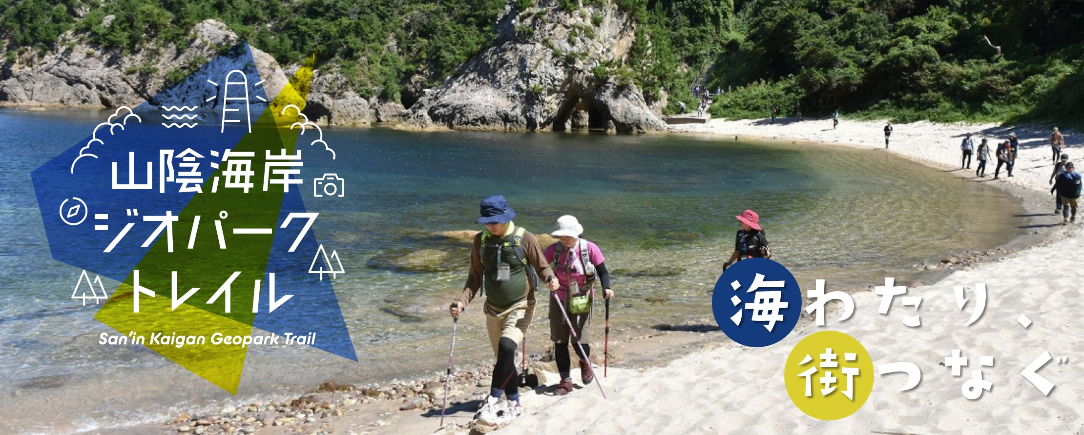
山陰海岸ジオパークを知る

What is the San’in Kaigan Geopark Trail ?

A major feature of the San’in Kaigan Geopark Trail is that you can enjoy walking in the San'in Kaigan Geopark with a variety of coastal terrains with rock of strange shape, sea caves, and spectacular views of cliffs. In addition, because most of the routes were set overlapping on the nature trails, it is a course where you can fully enjoy the original scenery of the coast of the Sea of Japan, such as fishing villages, history and culture, as well as the rich nature. A trail with a total length of 230.9km consisting of 27 courses was established for all the hikers from the hikers who enjoy diverse topography to family hikers. This trail, continuing from Aoya (Tottori City, Tottori prefecture) in the west to Kyogamisaki Cape (Kyotango City, Kyoto Prefecture) in the east, is a "coast trail" (with coastline and mountain road), a rare trail at home and abroad.

山陰海岸ジオパークトレイルって?

Course list

Course 1: Walk while feeling the ancient volcanic eruption and the erosive power of the sea (Aoya Station -Tottori City Shikano Orai Community Center “Dream”).

コース1:大昔の火山噴火と海の侵食力を感じながら歩く

It is a course connecting Nagaobana protruding into the Sea of Japan and Shikano, a castle town in the mountains. Along the way, you can overlook the Hakuto Kaigan Coast, which is known for the legend of “White Rabbit of Inaba, from Uomidai. At Nagaohana, you can enjoy the powerful rocky coast.

Rate of difficulty:★★★☆☆ 
Total length of trail:16.0km 
Estimated walking time:300min 
Difference in height:About67m

The nearest station
Aoya Station

Course 2: Follow the historical path that connects the castle town and the hot spring town of the post station (Tottori City Shikano Orai Community Center “Dream”-Yoshioka Hot Springs).

コース2:城下町と宿場の温泉街をつなぐ歴史の道を行く

You will mainly walk along the historical road “Shikano Orai (Traffic)” connecting Shikano Castle Town and Yoshioka Hot Springs, once flourished as the post station。 The castle town of Shikano, which was constructed about 400 years ago, retains the remnants of the time when it prospered as a transportation hub.

Rate of difficulty:★★★☆☆ 
Total length of trail:9.7km 
Estimated walking time:130min 
Difference in height:About224m

The nearest station

Course 3: Walk along the lagoon closed by sand dunes (Yoshioka Hot Springs-Tottori Station)

コース3:砂丘に閉ざされたラグーンのほとりを歩く

You walk while looking at Koyamaike Pond which is the largest pond in Japan among places classified as “Pond”. The entrance to the inner bay connected to the Sea of Japan was blocked by the development of sand dunes and it became a brackish water pond. Yoshioka Hot Spring, which is said to have been discovered during the Heian period, also has a footbath, so you can heal the tiredness of your trip.

Rate of difficulty:★★☆☆☆ 
Total length of trail:11.0km 
Estimated walking time:170min 
Difference in height:About160m

The nearest station
Tottori Station

Course 4: Walk around the ruins of Tottori Castle, which retains the appearance of various castles from the Middle Ages to the early Recent Period (Tottori Station – Mt. Kyushu - Maniji Temple).

コース4:中世から近世に至る多様な城の姿を残す鳥取城跡とその周辺を歩く

This course goes through the mountains, along the Chugoku Natural Trails. With log bridges, trails along a river, trails in cedar forests, and other features, this course is filled with the joy of experiencing nature. Despite many up and downs, the top of Mt. Kyusho with the remains of Tottori Castle is, also, a must-visit point for viewing Tottori City.

Rate of difficulty:★★★★☆ 
Total length of trail:8.3km 
Estimated walking time:190min 
Difference in height:About280m

The nearest station
Tottori Station

Course 5: Walk along the mysterious pond besides the sand dunes and the sacred Maniji Temple (Maniji Temple -Tanegaike -Tottori Sand Dunes West Resting House)

コース5:砂丘のキワの神秘の池と霊場摩尼寺を歩く

Walk along the pear picking road, passing through the promenade and the pear farm in Yuyama, Fukube-cho, while looking sideways at the Tanegaike Pond on the edge of the Sand Dunes. You will walk on the forest road for a while, but it is an easy course because it is paved road.

Rate of difficulty:★★☆☆☆ 
Total length of trail:9.0km 
Estimated walking time:120min 
Difference in height:About163m

The nearest station

Course 6: Walk through the "Tottori Sand Dunes", a miraculous sculptural beauty created by sand and wind (Tottori Sand Dunes West Resting House - Tottori Sand Dunes – Iwado Kaigan Coast Isaribi Park)

コース6:砂と風による奇跡の造形美「鳥取砂丘」を歩く

It is a course crossing the Tottori Sand Dunes. Along the way, after climb up the 47-meter-high "Umanose" you will see the vast Tottori Sand Dunes and the distant coastline. Also, from the Tottori Sand Dunes Visitor Center to Iwato, you will walk on the promenade along the sandy beach while looking at the Sea of Japan and the Chinese shallot fields of the Sand Dunes.

Rate of difficulty:★★☆☆☆ 
Total length of trail:7.1km 
Estimated walking time:100min 
Difference in height:About70m

The nearest station

Course 7: Experiencing two different types of coasts, sandy beach coast and rocky coast (Iwado Kaigan Coast Isaribi Park – Otani Kaigan Coast – Uradome Kaigan Coast Pier for Island Cruise).

コース7:砂浜海岸と岩石海岸の2つの異なる海岸を体感

You will walk in the mountain along the coast of Mt. Shichiyama. From the observation rest area, you can see the Chinese Shallot fields and the Tottori Sand Dunes, and on sunny days you can see Mt. Daisen in the distance. In addition, it is a course where you can see the characteristics of the Sanin coast, where the sandy beach and the rocky coast occur side by side.

Rate of difficulty:★★★☆☆ 
Total length of trail:3.5km 
Estimated walking time:100min 
Difference in height:About229m

The nearest station

Course 8: Enjoy the cliffs of white granite, rocks with characteristic shape, the coast with continuous occurrences of sea gates and the clear transparent sea (Uradome Kalgan Coast Pier for Island Cruise – Ajiro – Kamogaiso – Shirawara Kaigan Coast Parking Lot).

コース8:白い花こう岩の断崖、奇岩、洞門が続く海岸と透き通る海を楽しむ

You will walk on a trail along the coast. The isolated islands of Natanegoto Islands and sea caves of such as Sengan Matsushima Island have been formed by erosion of fractured granite generated by tectonic movement related to the development of the Sea of Japan.At Ajiro fishing port, you will encounter a scene of drying squids. You should pay an attention to the difference here in the drying method from Tajiri Port on the east side of the Kamogaiso coast.

Rate of difficulty:★★☆☆☆ 
Total length of trail:3.9km 
Estimated walking time:90min 
Difference in height:About90m

The nearest station

Course 9: Walk through a fishing village located on the fragmentary edge of the Eurasian continent (Shirawara Kaigan Coast Parking Lot – Makidani – San’in Kaigan Geopark Museum of the Earth and Sea)

コース9:ユーラシア大陸の切れ端に佇む漁村を歩く

It is a course to walk on paved roads and sandy beaches. From the Shirawara coast to Tajiri, you can enjoy the beautiful scenery of the blue sea and white cliffs and reefs. The area consists of granite that was formed when Japan was a part of the continent, so to speak, the Japanese islands are pieces of the continent. At Tajiri Port, we walk in the narrow alleys of a fishing village where houses are densely packed in the valley.

Rate of difficulty:★☆☆☆☆ 
Total length of trail:4.1km 
Estimated walking time:100min 
Difference in height:About54m

The nearest station
The San’in Kaigan Geopark Museum of the earth and Sea

Course 10: Enjoy Mountain walks and superb sandy beaches (San’in Kaigan Geopark Museum of the Earth and Sea – Obaneo – Higashihama Station)

コース10:山歩きと絶景の砂浜を楽しむ

It is a course walk on the Kinki Nature Trail along the coast of Haneo Cape. From the observatory on the hill, you can overlook the Uradome beach. You can enjoy beautiful sceneries of Nishiwaki Kalgan Coast, where the contrast between white granite and green pine is superb, and the Higashihama coast, where the white sand and blue sea are attractive.

Rate of difficulty:★★☆☆☆ 
Total length of trail:4.6km 
Estimated walking time:100min 
Difference in height:About104m

The nearest station
HIgashihama Station、The San’in Kaigan Geopark Museum of the earth and Sea

Course 11: Crossing the Nanasakayatoge Mountain Pass located on the old border between Tajima and Inaba regions (Higashihama Station – Igumi Residential Police Station).

コース11:但馬と因幡の旧国境にある七坂八峠を超える

Walk on the old Route 178, which crosses over the prefectural border between Tottori and Hyogo prefectures. This road, where you can experience the jagged coastline of the ria coast, is called Nanasakayatoge Mountain Pass and has been a difficult place for transportation since ancient times. From the observatory, you can enjoy the spectacular view of Igumi fishing port and Higashihama Beach.

Rate of difficulty:★★☆☆☆ 
Total length of trail:5.8km 
Estimated walking time:130min 
Difference in height:About115m

The nearest station
HIgashihama Station、Igumi Station

Course 12: Enjoy the sunset over the rocky reefs (Igumi Residential Police Station – Moroyose Fishing Port)

コース12:岩礁群に沈む夕日を楽しむ

Walk on the Route 128 along the coast while seeing rocky reefs. The rough and powerful rocky reefs protruding into the Sea of Japan were created by the erosion of lava and other rocks generated by volcanic activities during the development of the Sea of Japan. The Anami Kaigan Coast along the way is also popular as a sunset spot.

Rate of difficulty:★☆☆☆☆ 
Total length of trail:4.6km 
Estimated walking time:90min 
Difference in height:About100m

The nearest station
Igumi Station

Course 13: Enjoy the spectacular view of the Sea of Japan and the modern cityscape on the sandbar (Moroyose Fishing Port – Mt. Shiroyama – Mt. Kannon – Soobuji Temple)

コース13:日本海の絶景と砂州の上の近世の街並みを楽しむ

It is a course that mainly walks through the towns "Moroyose" and "Hamasaka" built on the sandbar. Along the way, you can see the 270-degree panoramic view of the Sea of Japan from the Yajogahana Lighthouse in Shiroyama. In addition, you can see the streets around Ajiwara Komichi Road that give you a glimpse of the lives of people in the early modern period. At the top of Mt. Kannon, you can overlook the city of Hamasaka and Tajima Mihonoura.

Rate of difficulty:★★★★☆ 
Total length of trail:10.4km 
Estimated walking time:220min 
Difference in height:About245m

The nearest station
Moroyose Station、Hamasaka Station

Course 14: Walk through mysterious villages on ria coast (Shoobuji Temple – Roadside Station Amarube)

コース14:リアス海岸のミステリアスな集落を歩く

This is the longest of the 27 courses and a paved road in the mountains. From the observatory along the way and the Amarubesaki Lighthouse, you can see the rough and varied cliffs of Tajima Mihonoura. Along the way, you will pass through the Mio village in the cove on the ria coast and Misaki village, a traditional settlement of the Heike Family.

Rate of difficulty:★★★★☆ 
Total length of trail:21.4km 
Estimated walking time:450min 
Difference in height:About332m

The nearest station
Hamasaka Station、Amarube Station、Amarube Roadside Station

Course15: Walk through Satoyama, the mountain near village, overlooking 41.5m high Amarube Viaduct (Roadside Station Amarube – Yoroi Station)

コース15:高さ41.5メートルの余部橋梁を望む里山を歩く

You walk from Amarube Roadside Station to Yoroi Station through Takanosu no Mori Trail. The Takanosu no Mori Trail, about 2.8km long, is well maintained trail and it is relatively easy to walk even for beginners. Along the way, you can see the Amarube Viaduct from above. On your way back, it is recommended to take a train from Yoroi Station to Amarube Station to experience the Amarube Viaduct.

Rate of difficulty:★★☆☆☆ 
Total length of trail:2.8km 
Estimated walking time:80min 
Difference in height:About150m

The nearest station
Amarube Station、Amarube Roadside Station、Yoroi Station

Course 16: Enjoy the footprints that tell us about the environment during periods of the spreading of the Sea of Japan (Yoroi Station – Shiokaze Koen Park)

コース16:日本海拡大期の環境を語る足跡たちを楽しむ

This is a course you can enjoy the beauty of the sea coast such as Tajima Matsushima.Along the way, you can find the outcrop of sedimentary rocks with fossils of animal footprints left during the time when the Japanese archipelago began to leave the Eurasian Continent about 20 million years ago. You can imagine the environment at the time when the depressions on the continental edge became rivers and lakes, and animals gathered on the waterside.

Rate of difficulty:★★☆☆☆ 
Total length of trail:8.5km 
Estimated walking time:180min 
Difference in height:About122m

The nearest station
Yoroi Station、Kasumi Station

Course 17: Enjoy the art of ancient volcanoes and rough seas (Shiokaze Koen Park – Shibayama Station)

コース17:太古の火山と荒波の芸術を堪能しよう

It is a course where you can see the artistic coastal topography created by the rough waves carving the lavas generated by active volcanic activity when the Japanese archipelago began to leave the continent. The mountain road that connects Imagoura, which used to be the port of call for the Kitamaebune ship, and Shibayama Port is still loved as the "Odaishi--michi".

Rate of difficulty:★★★★☆ 
Total length of trail:10km 
Estimated walking time:200min 
Difference in height:About145m

The nearest station
Kasumi Station、Shibayama Station

Course 18: Walk through the natural good port which used to be the port of call for the Kitamaebune ship (Shibaya Station – Satsu Station)

コース18:北前船が寄港した天然の良港を歩く

It is a short course that connects stations through mountain roads and prefectural roads while looking down at Shibayama Port. The Shibayama Port, which is also famous for crab fishing, is a natural good port, located in a deep bay on the ria coast, and in the old days it was the wind waiting port of the Kitamaebune ship and played an important role in maritime transportation as a port of call.

Rate of difficulty:★★☆☆☆ 
Total length of trail:2.8km 
Estimated walking time:70min 
Difference in height:About135m

The nearest station
Shibayama Station、Satsu Station

Course 19: Go around the sculptures created by the sea (Sazu Station – Kitamae Kan Museum).

コース19:海が作った彫刻を巡る

From the guest house street of Satsu to the foot of the Nekozaki Peninsula, this is a course you can enjoy sculptures created by the sea such as Yodo Sea Cave and Hasakari Rock (Stuck Boulder). Along the way, you can climb the Uomidai made of logs and take a closer look at the train coming out of the tunnel. A lot of fun.

Rate of difficulty:★★☆☆☆ 
Total length of trail:13.1km 
Estimated walking time:210min 
Difference in height:About84m

The nearest station
Satsu Station、Takeno Station

Course 20: Walk through a small fishing village with Green Tuff generated by submarine volcanic activity (Kitamae Kan Museum = Kinosaki Marine World).

コース20:海底火山活動でできたグリーンタフのある小さな漁村を歩く

It is a course you can enjoy a beautiful white sand beach and a small fishing village in a cove on the ria coast. Along the way, at the fishing port of Takuhi, you can find the Green Rocks (Green Tuff) formed by submarine volcanic activity. There is a shrine in cave with strange landscape created by weathering and erosion and whale bones are dedicated to it.

Rate of difficulty:★★☆☆☆ 
Total length of trail:9.5km 
Estimated walking time:150min 
Difference in height:About160m

The nearest station
Takeno Station

Course 21: You will pass through the wetland where Oriental White Stork stops by and walk the mountain trail that has almost returned to the forest (Kinosaki Marine World = Shotenkyo)

コース21:コウノトリ立ち寄る湿地とほぼ森に還った山道を越える

This is a course to pass through Tai Wetland and to cross the border between Hyogo and Kyoto Prefecture along the mountain trail that has almost returned to the forest. In the Tai Wetlands along the way, you may have a chance to see Oriental White Storks, that were once extinct, returned to the wild. You can also see the Tango Peninsula in Kyoto Prefecture from the guide center on the Hiyoriyama coast.

Rate of difficulty:★★★☆☆ 
Total length of trail:12.6km 
Estimated walking time:200min 
Difference in height:About163m

The nearest station
Shotenkyo Station

Course 22: Walk on the longest beach in Northern Kinki Area where you can feel the roundness of the earth (Shoutenkyo – Hamazume Yuhigaura Campsite)

コース22:地球の丸みを感じる北近畿最大のロングビーチを歩く

This is a course walk on the longest beach in northern Kinki Area. Along the way, you will walk about 6km long Shoutenkyo Sand Beach, which is a sandbar separating the Sea of Japan and Kumihama Bay. In the area near Hakoishikaigan Coast, more than 50 species of precious beach plant, including endemic species of Japan, grow naturally and, in spring, you can enjoy the blue sea and colorful flowers.

Rate of difficulty:★★☆☆☆ 
Total length of trail:6.5km 
Estimated walking time:130min 
Difference in height:About10m

The nearest station
Shotenkyo Station、Yuhigaura-Kitsuonsen Station

Course 23: Walk on the road toward the beautiful sunset to visit Shizuka Gozen (Hamazume Yuhigaura Campsite – Hatchouhama Seaside Park)

コース23:静御前を訪ねる美しい夕日を目指す道を歩く

This is a course that goes through the Shizu Shrine, which enshrines Shizuka Gozen (a beautiful heroine of the medieval times) who was born in Amino Town, Kyotango City. Along the way, you can also see Goshikihama, where the wave-cut terrace, composed of tuff with volcanic rock fragments of various colors, spreads, and Yuhigaura, which is famous for its beautiful sunsets. There is also a monument of the meridian tower, which indicates that it is the northernmost point of Japan where 135 degrees east longitude (meridian) passes.

Rate of difficulty:★★★☆☆ 
Total length of trail:11.9km 
Estimated walking time:260min 
Difference in height:About150m

The nearest station
Yuhigaura-Kitsuonsen Station、Amino Station

Course 24: Experience the Japan's largest singing sand beach and Suishohama beach (Hatchouhama Seaside Park – Kotohikihama Kaketsu Camp)

コース24:日本最大級の鳴き砂の浜と水晶浜を体感

It is a course you can enjoy the beautiful scenery of the sandy beach and the Sea of Japan. Along the way, you will be attracted by each characteristic sandy beach, such as Kotohikihama, which is a 1.8km long singing sand beach designated as national natural monument and scenic spot, and Crystal Beach, which composed of a particularly large amount of quartz sand containing high-temperature quartz.

Rate of difficulty:★☆☆☆☆ 
Total length of trail:4.2km 
Estimated walking time:90min 
Difference in height:About54m

The nearest station
Amino Station

Course 25: Walk the land related to Empress Hashiudo while looking at the huge rock "Tateiwa" (Kotohikihama Kaketsu Campsite – Roadside Station Tenki Tenki Tango)

コース25:巨岩「立岩」を眺めながら間人皇后ゆかりの地を歩く

It is a course to walk in the land of Taiza, the name of place is said to be given by Empress Hashiudo. Along the way, you can enjoy the geological features created by ancient volcanic activities, such as the gigantic andesite rock "Tateiwa", which has a circumference of about 1 km, and the dome-shaped strata on the Taiza Coast and Shiroshma.

Rate of difficulty:★★★☆☆ 
Total length of trail:10.7km 
Estimated walking time:220min 
Difference in height:About23m

The nearest station
Tenki Tenki Tango Roadside Station

Course 26: Walk along the coastline to experience ancient stories (Roadside Station Tenki Tenki Tango – Takashima Auto Campsite)

コース26:古代の物語に触れる海岸線を歩く

It is a course that passes through the Onaru Ancient Burial Mounds on the coastal terrace overlooking the Sea of Japan. During the course, you can also see the Byobuiwa Rock (Folding Screen Rock), the rocks rising from the surface of the sea during the course. From Cape Inugasaki in the middle, you can see the beautiful coastline of Tango Matsushima, which was named because it resembles Matsushima in Miyagi prefecture, one of the three most scenic spots in Japan.

Rate of difficulty:★★☆☆☆ 
Total length of trail:9.9km 
Estimated walking time:200min 
Difference in height:About145m

The nearest station
Tenki Tenki Tango Roadside Station

Course 27: Tour the rice terraces overlooking the sea from the northernmost land of Kinki (Takashima Auto Campsite – Kyogamisaki Parking Lot)

コース27:近畿最北端の地から海を望む棚田を巡る

It is a course to walk on the marine terrace formed by the uplift of abrasion platform. The Kyogamisaki Cape, the end point of the trail, is the northernmost land of Kinki, and you can see dacite with well-developed columnar joints at the tip of the cape. From Kyogamisaki, you can see the Sodeshi rice terraces, which was selected as one of the "100 Best Rice Terraces in Japan"

Rate of difficulty:★★☆☆☆ 
Total length of trail:9.0km 
Estimated walking time:180min 
Difference in height:About83m

The nearest station
About 70 minutes by car from Mineyama Station to Kyogamisaki bus stop of Tankai Bus