San’in Kaigan UNESCO Global Geopark San’in Kaigan UNESCO Global Geopark

  • Home
  • Outline
    • Outline of Japan and Global Geopark
    • Overview of San’in Kaigan Geopark
    • Valuable and beautiful Geoheritages
    • International geological significance
    • Japanese archipelago separated from the continent
    • Wealth of Ecosystem
    • Unique people’s lives brought about by Geo
  • Geological
    Heritage
    • Kyotango City
    • Toyooka City
    • Kami Town
    • Shin'onsen Town
    • Iwami Town
    • Tottori City
  • Related
    facilities
    • San’in Kaigan Geopark Kyotango City Information Center
    • Genbudo park
    • Kami Town Geopark &Marine Culture Center
    • Shin’onsen Town Sanin Kaigan Geopark Center
    • San’in Kaigan Geopark Museum of the Earth and Sea
    • Iwami Town Nagisa Community Center
    • Tottori Sand Dunes Geopark Visitor Center
    • Aoya Folk Museum
  • Model
    course
    • San’in Kaigan Geopark Trail
    • Walk & Drive Map
  • Practices &
    Activities
  • Operating
    organization
    • Greetings from the representative
    • Introduction of Managing Board and Steering Committee
    • Introduction of constituent groups
    • Introduction of the secretariat “San’in Kaigan Promotion Council”
  • Download
メニュー
  • Japanese

Geological HeritageKyotango City

Tateiwa Rock and Onaru Burial Mound

You can learn about the history of Tateiwa Rock and Tango (Takeno Shrine and the tumuli) and the legend of the extermination of oni (ogres) in this region. Here you can learn about the romantic history of this area and the spectacular landscape of the Geosite.
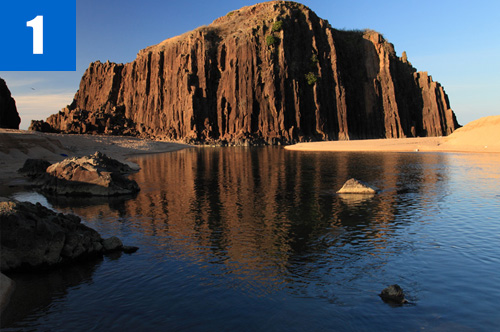
(1)Tateiwa Rock
There is a gigantic andesite rock at the mouth of the Takeno River, which shows a striking contrast with the white-sand beach. A legend says that an "oni" (ogre) was confined beneath the rock and you can hear the oni’s weeping during winter.

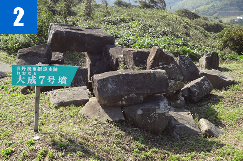
(2)Onaru Burial Mounds
A group of 18 tumuli is located on the Onaru Coastal Terrace. Horizontal stone chambers are built using andesite rocks of columnar joints quarried from the surrounding area. From the top of the plateau, you can enjoy the view of Tateiwa Rock.
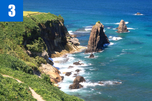
(3)Byobuiwa Rock
Strange-looking rocks resembling folding screens stand in front of the coastal cliffs. These plate-shaped rocks penetrate the strata below. You can observe a range of similar-looking islets toward the open sea.

(4)Museum of the Ancient City of Tango
This museum mainly exhibits archaeological artifacts such as stone tools, earthenware, and gemstones excavated from the ruins of Kyotango City.

Info.

Tenki Tenki Tango Roadside Station (San'in Kaigan Geopark Kyotango City Information Center)

TEL

0772-75-1411

URL
Geological Heritage
前の記事
次の記事
  • Home
  • Outline
    • Outline of Japan and Global Geopark
    • Overview of San’in Kaigan Geopark
    • Valuable and beautiful Geoheritages
    • International geological significance
    • Japanese archipelago separated from the continent
    • Wealth of Ecosystem
    • Unique people’s lives brought about by Geo
  • Geological
    Heritage
    • Kyotango City
    • Toyooka City
    • Kami Town
    • Shin'onsen Town
    • Iwami Town
    • Tottori City
  • Related
    facilities
    • San’in Kaigan Geopark Kyotango City Information Center
    • Genbudo park
    • Kami Town Geopark &Marine Culture Center
    • Shin’onsen Town Sanin Kaigan Geopark Center
    • San’in Kaigan Geopark Museum of the Earth and Sea
    • Iwami Town Nagisa Community Center
    • Tottori Sand Dunes Geopark Visitor Center
    • Aoya Folk Museum
  • Model
    course
    • San’in Kaigan Geopark Trail
    • Walk & Drive Map
  • Practices &
    Activities
  • Operating
    organization
    • Greetings from the representative
    • Introduction of Managing Board and Steering Committee
    • Introduction of constituent groups
    • Introduction of the secretariat “San’in Kaigan Promotion Council”
  • Download
  • Japanese