San’in Kaigan UNESCO Global Geopark San’in Kaigan UNESCO Global Geopark

  • Home
  • Outline
    • Outline of Japan and Global Geopark
    • Overview of San’in Kaigan Geopark
    • Valuable and beautiful Geoheritages
    • International geological significance
    • Japanese archipelago separated from the continent
    • Wealth of Ecosystem
    • Unique people’s lives brought about by Geo
  • Geological
    Heritage
    • Kyotango City
    • Toyooka City
    • Kami Town
    • Shin'onsen Town
    • Iwami Town
    • Tottori City
  • Related
    facilities
    • San’in Kaigan Geopark Kyotango City Information Center
    • Genbudo park
    • Kami Town Geopark &Marine Culture Center
    • Shin’onsen Town Sanin Kaigan Geopark Center
    • San’in Kaigan Geopark Museum of the Earth and Sea
    • Iwami Town Nagisa Community Center
    • Tottori Sand Dunes Geopark Visitor Center
    • Aoya Folk Museum
  • Model
    course
    • San’in Kaigan Geopark Trail
    • Walk & Drive Map
  • Practices &
    Activities
  • Operating
    organization
    • Greetings from the representative
    • Introduction of Managing Board and Steering Committee
    • Introduction of constituent groups
    • Introduction of the secretariat “San’in Kaigan Promotion Council”
  • Download
メニュー
  • Japanese

Geological HeritageKyotango City

Tango Matsushima Islands

You can enjoy a beautiful landscape of coastal terraces and a multitude of islets. There is a sandy beach below the coastal terraces. During summer, many people visit the beach for sea bathing.

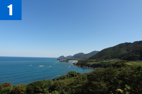
(1)Tango Matsushima Islands
This beautiful coast with coastal dunes and coastal terraces resembles Matsushima Islands in Miyagi Prefecture. This is why the coast is called Tango Matsushima.

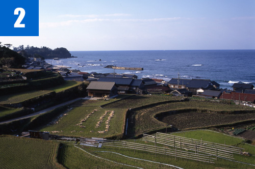
(2)Rice Terraces of Sodeshi
There are about 400 rice paddies utilizing the geological features of coastal terraces. They have been selected as one of the 100 best rice terraces in Japan by the Ministry of Agriculture, Forestry, and Fisheries. In recent years, students of universities in Kyoto have cooperated in the preservation of these terraced rice paddy fields.
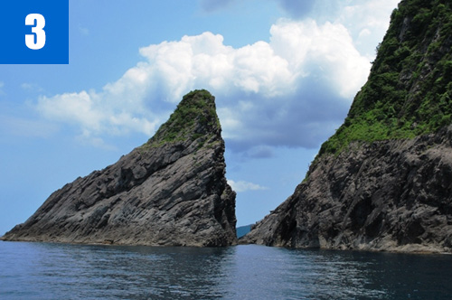
(3)Inugasaki Cape
The cape is made of andesite. The cape is called Inugasaki--literally "dog cape"--because its shape resembles that of a crouching dog. You can enjoy seasonal flowers on the cape. With a marine taxi, you can visit a coastal cave called "Ai-no-dokutsu" ("love cave").

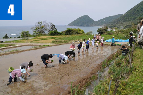
(4)Revitalization Project of Rice Terraces of Sodeshi
Rice Terraces of Sodeshi had previously been fallow for years. Now you can experience planting and harvesting rice in these rice paddies. Students of universities in the Keihanshin region and volunteers gather to hand-plant rice seedlings in spring, and harvest rice in autumn.

Info.

Tenki Tenki Tango Roadside Station (San'in Kaigan Geopark Kyotango City Information Center)

TEL

0772-75-1411

URL
Geological Heritage
前の記事
次の記事
  • Home
  • Outline
    • Outline of Japan and Global Geopark
    • Overview of San’in Kaigan Geopark
    • Valuable and beautiful Geoheritages
    • International geological significance
    • Japanese archipelago separated from the continent
    • Wealth of Ecosystem
    • Unique people’s lives brought about by Geo
  • Geological
    Heritage
    • Kyotango City
    • Toyooka City
    • Kami Town
    • Shin'onsen Town
    • Iwami Town
    • Tottori City
  • Related
    facilities
    • San’in Kaigan Geopark Kyotango City Information Center
    • Genbudo park
    • Kami Town Geopark &Marine Culture Center
    • Shin’onsen Town Sanin Kaigan Geopark Center
    • San’in Kaigan Geopark Museum of the Earth and Sea
    • Iwami Town Nagisa Community Center
    • Tottori Sand Dunes Geopark Visitor Center
    • Aoya Folk Museum
  • Model
    course
    • San’in Kaigan Geopark Trail
    • Walk & Drive Map
  • Practices &
    Activities
  • Operating
    organization
    • Greetings from the representative
    • Introduction of Managing Board and Steering Committee
    • Introduction of constituent groups
    • Introduction of the secretariat “San’in Kaigan Promotion Council”
  • Download
  • Japanese