San’in Kaigan UNESCO Global Geopark San’in Kaigan UNESCO Global Geopark

  • Home
  • Outline
    • Outline of Japan and Global Geopark
    • Overview of San’in Kaigan Geopark
    • Valuable and beautiful Geoheritages
    • International geological significance
    • Japanese archipelago separated from the continent
    • Wealth of Ecosystem
    • Unique people’s lives brought about by Geo
  • Geological
    Heritage
    • Kyotango City
    • Toyooka City
    • Kami Town
    • Shin'onsen Town
    • Iwami Town
    • Tottori City
  • Related
    facilities
    • San’in Kaigan Geopark Kyotango City Information Center
    • Genbudo park
    • Kami Town Geopark &Marine Culture Center
    • Shin’onsen Town Sanin Kaigan Geopark Center
    • San’in Kaigan Geopark Museum of the Earth and Sea
    • Iwami Town Nagisa Community Center
    • Tottori Sand Dunes Geopark Visitor Center
    • Aoya Folk Museum
  • Model
    course
    • San’in Kaigan Geopark Trail
    • Walk & Drive Map
  • Practices &
    Activities
  • Operating
    organization
    • Greetings from the representative
    • Introduction of Managing Board and Steering Committee
    • Introduction of constituent groups
    • Introduction of the secretariat “San’in Kaigan Promotion Council”
  • Download
メニュー
  • Japanese

    Geological HeritageKyotango City

    Taiza Kaigan Coast

    Under the sea off the Tango Peninsula, there lies an undulating seabed that steeply sinks 200 meters below the sea surface at a point only 15 km off the coastline. This sea area is an excellent fishing area for snow crabs. The Taiza Inlet is a natural harbor formed by a complex erosion of rocks; Taiza thus developed as a fishing port. The port once prospered as an important junction port on the Kitamaebune―a shipping route to and from the north of Japan. You can still find the remains of bollards for mooring ships in and around the Shiroshima area. There is a legend about the origin of the name “Taiza.” The legend says that Empress Hashiudo (間人), the mother of Shotoku Taishi, stayed in this area. It is said that, when the empress left the area, she gave it her own name, Hashiudo. However, the people in the area were too humble to call their land by the name of the empress, so they began to call the area “Taiza” (meaning “leaving”) instead.

    (1)Nochigahama Beach
    The beach has pink or reddish-colored sand. The sand washed down from the upstream is derived from granite rocks and contains a high content of a pink mineral called potash feldspar. This mineral makes the sand reddish in color. The sea water is very clear and suitable for sea bathing.

    (2)Shiroshima
    A castle once stood on this small islet (4 km in circumference; highest point: 21 meters above sea level). This is why the islet is called Shiroshima―literally “castle island.” Today, the islet is used as a nature park. You can observe coastal terraces and potholes on the northern side of the islet. You can also observe the “domes,” a geological phenomenon of raised strata in various places on the islet.

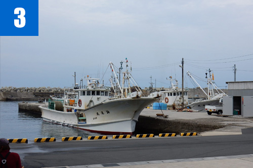
    (3)Taiza Fishing Port
    Taiza Port developed along the deeply-indented coastline. Fishermen from this port catch crabs in the sea off Kyogamisaki, and bring them to the port on the same day. This is why these crabs are so fresh and known as "Taiza Crabs." * Contact the Fishery Association to see the crab fishing.

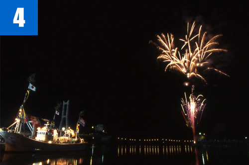
    (4)Taiza Port Festival (July)
    All the ships in the port light up, the streets bustle with rows of night stalls, and fireworks light the sky. This is a fishermen’s festival to pray for safety on the sea. Now this festival is open to visitors as a sightseeing event.

    Info.

    Tenki Tenki Tango Roadside Station (San'in Kaigan Geopark Kyotango City Information Center)

    TEL

    0772-75-1411

    URL
    Geological Heritage
    前の記事
    次の記事
    • Home
    • Outline
      • Outline of Japan and Global Geopark
      • Overview of San’in Kaigan Geopark
      • Valuable and beautiful Geoheritages
      • International geological significance
      • Japanese archipelago separated from the continent
      • Wealth of Ecosystem
      • Unique people’s lives brought about by Geo
    • Geological
      Heritage
      • Kyotango City
      • Toyooka City
      • Kami Town
      • Shin'onsen Town
      • Iwami Town
      • Tottori City
    • Related
      facilities
      • San’in Kaigan Geopark Kyotango City Information Center
      • Genbudo park
      • Kami Town Geopark &Marine Culture Center
      • Shin’onsen Town Sanin Kaigan Geopark Center
      • San’in Kaigan Geopark Museum of the Earth and Sea
      • Iwami Town Nagisa Community Center
      • Tottori Sand Dunes Geopark Visitor Center
      • Aoya Folk Museum
    • Model
      course
      • San’in Kaigan Geopark Trail
      • Walk & Drive Map
    • Practices &
      Activities
    • Operating
      organization
      • Greetings from the representative
      • Introduction of Managing Board and Steering Committee
      • Introduction of constituent groups
      • Introduction of the secretariat “San’in Kaigan Promotion Council”
    • Download
    • Japanese