San’in Kaigan UNESCO Global Geopark San’in Kaigan UNESCO Global Geopark

  • Home
  • Outline
    • Outline of Japan and Global Geopark
    • Overview of San’in Kaigan Geopark
    • Valuable and beautiful Geoheritages
    • International geological significance
    • Japanese archipelago separated from the continent
    • Wealth of Ecosystem
    • Unique people’s lives brought about by Geo
  • Geological
    Heritage
    • Kyotango City
    • Toyooka City
    • Kami Town
    • Shin'onsen Town
    • Iwami Town
    • Tottori City
  • Related
    facilities
    • San’in Kaigan Geopark Kyotango City Information Center
    • Genbudo park
    • Kami Town Geopark &Marine Culture Center
    • Shin’onsen Town Sanin Kaigan Geopark Center
    • San’in Kaigan Geopark Museum of the Earth and Sea
    • Iwami Town Nagisa Community Center
    • Tottori Sand Dunes Geopark Visitor Center
    • Aoya Folk Museum
  • Model
    course
    • San’in Kaigan Geopark Trail
    • Walk & Drive Map
  • Practices &
    Activities
  • Operating
    organization
    • Greetings from the representative
    • Introduction of Managing Board and Steering Committee
    • Introduction of constituent groups
    • Introduction of the secretariat “San’in Kaigan Promotion Council”
  • Download
メニュー
  • Japanese

Geological HeritageKami Town

Kusube Valley

Lava, tuff, breccia caused by volcanic activity after the formation of the Japanese Archipelago are distributed. Valleys and waterfalls are formed by a variety of geological unit. Gentle slope of landslip land has been used for people’s living since old times. It is also known as the birthplace of Tajima cattle.

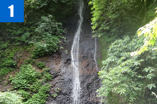
(1)Kusube Valley (Kanametaki Waterfalls, Sandantaki Waterfalls)
A waterfall flowing through tuff (welded tuff) rigidly hardened by heat.

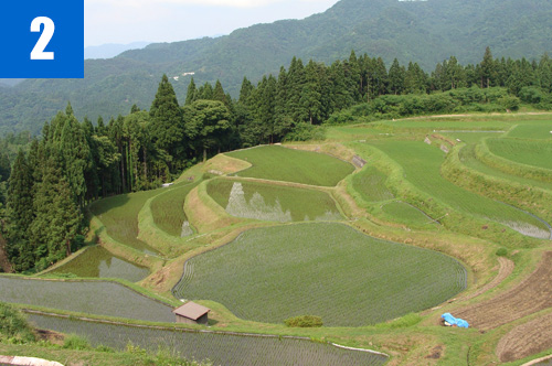
(2)Rice Terraces of Nukita (Ueyama)
One of the best 100 rice terraces in Japan. The land of past landslid is used.

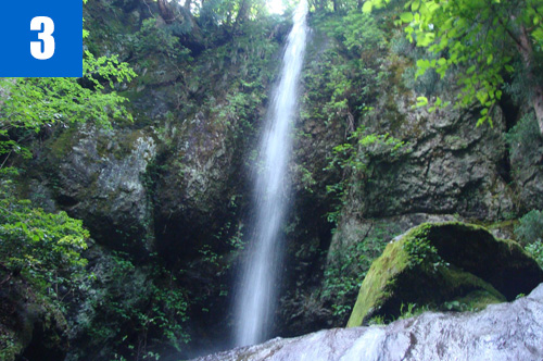
(3)Yoshitaki Waterfalls
A waterfall of almost 30m in height which is formed on the rock wall of andesite upstream of the Yada River. It is also called as Urami-no-Taki (rear-view waterfall) because you can see the backside of the waterfall because the water head is protruded. Along the path leading to Yoshitaki, there is a spot for viewing Shimaji Oike pond below, which was formed at the bottom of the scarp caused by landslide separating the basalt in the upper part of the terraced rice paddies.

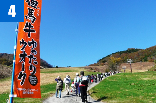
(4)Tajima Cattle Slow Walk (November)
A walking event is held to enjoy autumn leaves in Ojiro, the most beautiful village in Japan, while improving health. Local products can be tasted in the parking lot of the Ojiro skiing area where start and goal points are located.

Kami Town Ojiro Tourism Association

739-1 Kanzui Ojiro-ku Kami Town

TEL

0796-97-2250

URL
Geological Heritage
前の記事
次の記事
  • Home
  • Outline
    • Outline of Japan and Global Geopark
    • Overview of San’in Kaigan Geopark
    • Valuable and beautiful Geoheritages
    • International geological significance
    • Japanese archipelago separated from the continent
    • Wealth of Ecosystem
    • Unique people’s lives brought about by Geo
  • Geological
    Heritage
    • Kyotango City
    • Toyooka City
    • Kami Town
    • Shin'onsen Town
    • Iwami Town
    • Tottori City
  • Related
    facilities
    • San’in Kaigan Geopark Kyotango City Information Center
    • Genbudo park
    • Kami Town Geopark &Marine Culture Center
    • Shin’onsen Town Sanin Kaigan Geopark Center
    • San’in Kaigan Geopark Museum of the Earth and Sea
    • Iwami Town Nagisa Community Center
    • Tottori Sand Dunes Geopark Visitor Center
    • Aoya Folk Museum
  • Model
    course
    • San’in Kaigan Geopark Trail
    • Walk & Drive Map
  • Practices &
    Activities
  • Operating
    organization
    • Greetings from the representative
    • Introduction of Managing Board and Steering Committee
    • Introduction of constituent groups
    • Introduction of the secretariat “San’in Kaigan Promotion Council”
  • Download
  • Japanese