San’in Kaigan UNESCO Global Geopark San’in Kaigan UNESCO Global Geopark

  • Home
  • Outline
    • Outline of Japan and Global Geopark
    • Overview of San’in Kaigan Geopark
    • Valuable and beautiful Geoheritages
    • International geological significance
    • Japanese archipelago separated from the continent
    • Wealth of Ecosystem
    • Unique people’s lives brought about by Geo
  • Geological
    Heritage
    • Kyotango City
    • Toyooka City
    • Kami Town
    • Shin'onsen Town
    • Iwami Town
    • Tottori City
  • Related
    facilities
    • San’in Kaigan Geopark Kyotango City Information Center
    • Genbudo park
    • Kami Town Geopark &Marine Culture Center
    • Shin’onsen Town Sanin Kaigan Geopark Center
    • San’in Kaigan Geopark Museum of the Earth and Sea
    • Iwami Town Nagisa Community Center
    • Tottori Sand Dunes Geopark Visitor Center
    • Aoya Folk Museum
  • Model
    course
    • San’in Kaigan Geopark Trail
    • Walk & Drive Map
  • Practices &
    Activities
  • Operating
    organization
    • Greetings from the representative
    • Introduction of Managing Board and Steering Committee
    • Introduction of constituent groups
    • Introduction of the secretariat “San’in Kaigan Promotion Council”
  • Download
メニュー
  • Japanese

Geological HeritageKyotango City

Kumihama Bay and Tango Sand Dunes

In and around Kumihama, you can enjoy the beautiful landscape of Mt. Kabuto, Kumihama Bay, Shotenkyo, the Tango Sand Dunes, and other places of unique geological and topographical features that have been formed. They tell us how the earth has moved from the era when the Sea of Japan was formed to the present day. People have lived here utilizing these geological and topographical features. For example, in Kumihama Bay, which is a lagoon, oysters are cultured using floating rafts. Melons, watermelons, and sweet potatoes are grown on the sand dunes. Pears and peaches are grown on the fields on the coastal terraces and on the hills. Rice is grown on the wet land on the river banks and at the mouth of the river. You can learn about how people have developed agriculture and fishery to suit a wide variety of geological and topographical features.
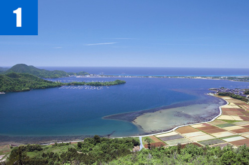
(1)Kumihama Bay
Kumihama Bay is an inland bay that was separated from the Sea of Japan with the development of the sandbar (Shotenkyo). While the Sea of Japan is very rough during winter, the waves and weather are relatively milder within the bay. Here the culture of oysters developed, and the landscape of a range of oyster rafts is registered on the list of Kyoto Prefecture’s Cultural Landscapes.
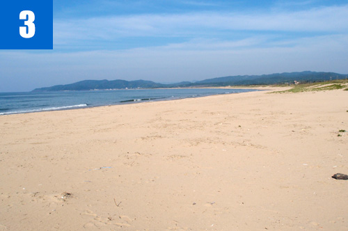
(2)Tango Dunes
Broad, sandy land consisting of old dunes and new dunes spread along the coastline from Minatomiya, Kumihama Town to Hamazume, Amino Town. Here you can observe various beach plants such as toteiran (Veronica ornata) and yusuge (Hemerocallis citrina).

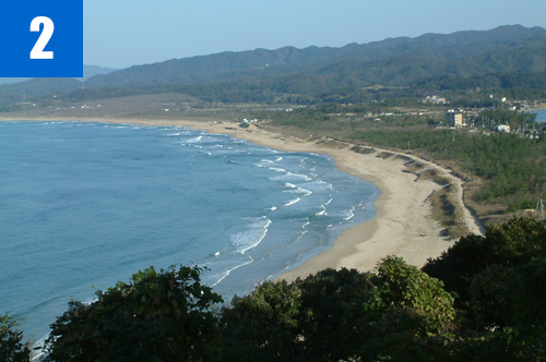
(3)Shotenkyo Sandbar
This is a sandbar that developed to separate Kumihama Bay from the Sea of Japan. The landscape of the sandbar resembles that of Amanohashidate, revered as one of the Three Greatest Views of Japan. This is why the sandbar is named Shotenkyo, meaning “Little Amanohashidate.” The 8-km-long sandy beach is the longest beach in the northern Kinki region.

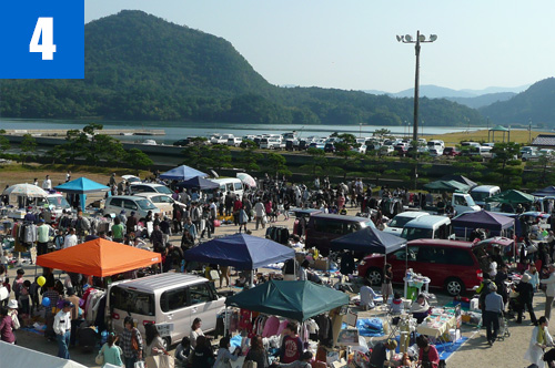
(4)Kumihama Marukajiri Festival (Oct.)
An industrial fair is held that gathers products produced in this town. You can also enjoy observing and shopping at a great flea market visited by as many as 10,000 people.

Kyotango City Tourism Association, Kumihama Town Tourism Information Office

772 Kumihama Town, Kyotango City

TEL

0772-82-1781

URL
Geological Heritage
前の記事
  • Home
  • Outline
    • Outline of Japan and Global Geopark
    • Overview of San’in Kaigan Geopark
    • Valuable and beautiful Geoheritages
    • International geological significance
    • Japanese archipelago separated from the continent
    • Wealth of Ecosystem
    • Unique people’s lives brought about by Geo
  • Geological
    Heritage
    • Kyotango City
    • Toyooka City
    • Kami Town
    • Shin'onsen Town
    • Iwami Town
    • Tottori City
  • Related
    facilities
    • San’in Kaigan Geopark Kyotango City Information Center
    • Genbudo park
    • Kami Town Geopark &Marine Culture Center
    • Shin’onsen Town Sanin Kaigan Geopark Center
    • San’in Kaigan Geopark Museum of the Earth and Sea
    • Iwami Town Nagisa Community Center
    • Tottori Sand Dunes Geopark Visitor Center
    • Aoya Folk Museum
  • Model
    course
    • San’in Kaigan Geopark Trail
    • Walk & Drive Map
  • Practices &
    Activities
  • Operating
    organization
    • Greetings from the representative
    • Introduction of Managing Board and Steering Committee
    • Introduction of constituent groups
    • Introduction of the secretariat “San’in Kaigan Promotion Council”
  • Download
  • Japanese