San’in Kaigan UNESCO Global Geopark San’in Kaigan UNESCO Global Geopark

  • Home
  • Outline
    • Outline of Japan and Global Geopark
    • Overview of San’in Kaigan Geopark
    • Valuable and beautiful Geoheritages
    • International geological significance
    • Japanese archipelago separated from the continent
    • Wealth of Ecosystem
    • Unique people’s lives brought about by Geo
  • Geological
    Heritage
    • Kyotango City
    • Toyooka City
    • Kami Town
    • Shin'onsen Town
    • Iwami Town
    • Tottori City
  • Related
    facilities
    • San’in Kaigan Geopark Kyotango City Information Center
    • Genbudo park
    • Kami Town Geopark &Marine Culture Center
    • Shin’onsen Town Sanin Kaigan Geopark Center
    • San’in Kaigan Geopark Museum of the Earth and Sea
    • Iwami Town Nagisa Community Center
    • Tottori Sand Dunes Geopark Visitor Center
    • Aoya Folk Museum
  • Model
    course
    • San’in Kaigan Geopark Trail
    • Walk & Drive Map
  • Practices &
    Activities
  • Operating
    organization
    • Greetings from the representative
    • Introduction of Managing Board and Steering Committee
    • Introduction of constituent groups
    • Introduction of the secretariat “San’in Kaigan Promotion Council”
  • Download
メニュー
  • Japanese

Geological HeritageKami Town

Imagoura

A calm cove which flourished as a port for Kitamaebune Ships (cargo ships sailing the sea of Japan in the Edo period). Currently, the site has a bathing beach with camping sites, which is popular as a seashore recreation spot. It is composed of volcanic rocks, pyroclastic flow deposits and river/lake deposits (alternated strata composed of sandstone and mudstone) dating from the time of early formation of the Sea of Japan.

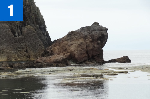
(1)Kaerujima Rock (Frog Island)
An island formed of andesite. Its frog-like shape is loved by local citizens and sailors.
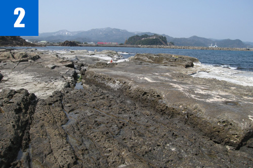
(2)Senjojiki
Wave-cut terrace developed on the tuff (pyroclastic flow deposit) accumulated during the time of the formation of the sea of Japan.
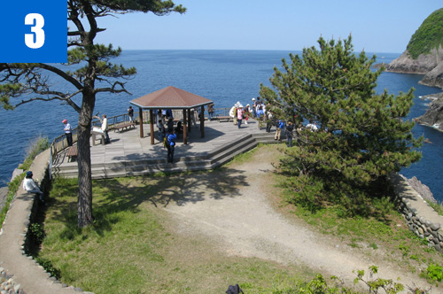
(3)Obikinohana Cape
A steeped cape formed of andesite at the northern end of Imagoura. There are Obiki rock tunnel and valleys formed by faults on the east side, and cracks of columnar joints are spreading to the brown rock walls and collapsing. It is a wonderful scenic place for viewing the scenic spots on the west side, Kasumi Kaigan Coast, and the whole area near the sea of Japan from the observatory at the tip of the cape.

(4)Imagoura Wakame Festival (May)
Tasting of Wakame (sea weed) hot pot, sale of marine products of Kasumi and Wakame rice balls are provided. You can collect Wakame with your hands and play on the seashore.

Kamicho Kasumi Tourist Association

1-1 Nanukaichi, Kasumi-ku, Kami Town

TEL

0796-36-1234

URL
Geological Heritage
前の記事
次の記事
  • Home
  • Outline
    • Outline of Japan and Global Geopark
    • Overview of San’in Kaigan Geopark
    • Valuable and beautiful Geoheritages
    • International geological significance
    • Japanese archipelago separated from the continent
    • Wealth of Ecosystem
    • Unique people’s lives brought about by Geo
  • Geological
    Heritage
    • Kyotango City
    • Toyooka City
    • Kami Town
    • Shin'onsen Town
    • Iwami Town
    • Tottori City
  • Related
    facilities
    • San’in Kaigan Geopark Kyotango City Information Center
    • Genbudo park
    • Kami Town Geopark &Marine Culture Center
    • Shin’onsen Town Sanin Kaigan Geopark Center
    • San’in Kaigan Geopark Museum of the Earth and Sea
    • Iwami Town Nagisa Community Center
    • Tottori Sand Dunes Geopark Visitor Center
    • Aoya Folk Museum
  • Model
    course
    • San’in Kaigan Geopark Trail
    • Walk & Drive Map
  • Practices &
    Activities
  • Operating
    organization
    • Greetings from the representative
    • Introduction of Managing Board and Steering Committee
    • Introduction of constituent groups
    • Introduction of the secretariat “San’in Kaigan Promotion Council”
  • Download
  • Japanese