San’in Kaigan UNESCO Global Geopark San’in Kaigan UNESCO Global Geopark

  • Home
  • Outline
    • Outline of Japan and Global Geopark
    • Overview of San’in Kaigan Geopark
    • Valuable and beautiful Geoheritages
    • International geological significance
    • Japanese archipelago separated from the continent
    • Wealth of Ecosystem
    • Unique people’s lives brought about by Geo
  • Geological
    Heritage
    • Kyotango City
    • Toyooka City
    • Kami Town
    • Shin'onsen Town
    • Iwami Town
    • Tottori City
  • Related
    facilities
    • San’in Kaigan Geopark Kyotango City Information Center
    • Genbudo park
    • Kami Town Geopark &Marine Culture Center
    • Shin’onsen Town Sanin Kaigan Geopark Center
    • San’in Kaigan Geopark Museum of the Earth and Sea
    • Iwami Town Nagisa Community Center
    • Tottori Sand Dunes Geopark Visitor Center
    • Aoya Folk Museum
  • Model
    course
    • San’in Kaigan Geopark Trail
    • Walk & Drive Map
  • Practices &
    Activities
  • Operating
    organization
    • Greetings from the representative
    • Introduction of Managing Board and Steering Committee
    • Introduction of constituent groups
    • Introduction of the secretariat “San’in Kaigan Promotion Council”
  • Download
メニュー
  • Japanese

Geological HeritageTottori City

Hamamura Hot Springs

This is a Geosite with a beach of squeaking sand that is about 5 km in length from east to west. Since olden times, people have lived here utilizing the unique geological features formed by the development of the sand dunes.

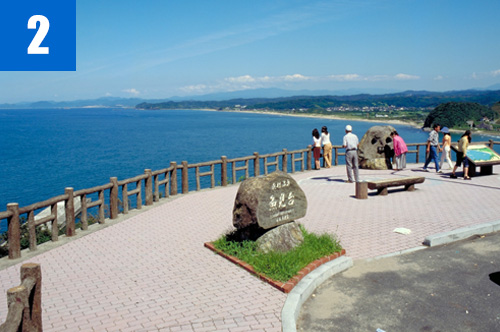
(1)Hamamura Kaigan Coast
This is a sandy beach that stretches from the Tatsumidai Observatory to Nagaohana. In this area, “Kaigarabushi,” a song about fishing for scallops, has been handed down. There are sand dunes behind the beach.

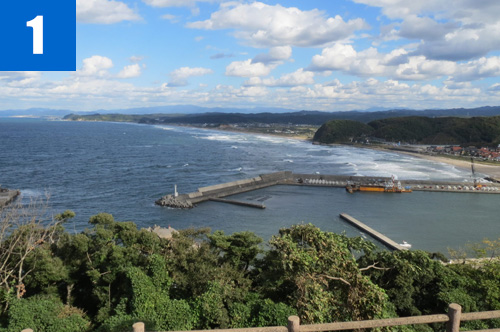
(2)Uomidai Observation Deck
This is a height on the east side of the Nagaohana. Uomidai (meaning “height for watching fish”) was named because an old fisherman shouted when he found a great shoal of sardines approaching.
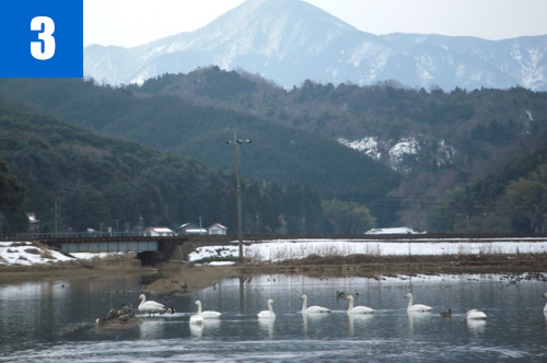
(3)Nikko Pond
This is a lagoon formed by the blocking of an inland bay by sand dunes. This area was reclaimed and developed into rice paddies by the feudal lord Kamei Korenori in the Sengoku Period. However, the lagoon appeared during winter. Even today, a lagoon appears in winter when the water is effluent, and many water birds gather at the lagoon.

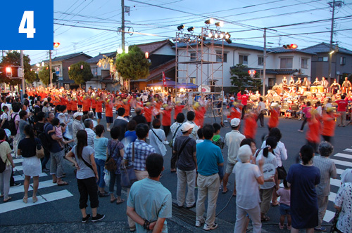
(4)Kaigarabushi Festival
This summer festival is held on the theme of “Kaigarabushi,” a song handed down in Ketaka Town. On the first evening of the festival, on the Funaiso Coast, fireworks are sent up from the sea to the sound of the sea waves. On the second day, local people dance the Soodori dance singing Kaigarabushi.

Ketaka Town Tourism Center

682-7 Katsumi, Ketaka Town, Tottori City

TEL

0857-82-0829

Geological Heritage
前の記事
次の記事
  • Home
  • Outline
    • Outline of Japan and Global Geopark
    • Overview of San’in Kaigan Geopark
    • Valuable and beautiful Geoheritages
    • International geological significance
    • Japanese archipelago separated from the continent
    • Wealth of Ecosystem
    • Unique people’s lives brought about by Geo
  • Geological
    Heritage
    • Kyotango City
    • Toyooka City
    • Kami Town
    • Shin'onsen Town
    • Iwami Town
    • Tottori City
  • Related
    facilities
    • San’in Kaigan Geopark Kyotango City Information Center
    • Genbudo park
    • Kami Town Geopark &Marine Culture Center
    • Shin’onsen Town Sanin Kaigan Geopark Center
    • San’in Kaigan Geopark Museum of the Earth and Sea
    • Iwami Town Nagisa Community Center
    • Tottori Sand Dunes Geopark Visitor Center
    • Aoya Folk Museum
  • Model
    course
    • San’in Kaigan Geopark Trail
    • Walk & Drive Map
  • Practices &
    Activities
  • Operating
    organization
    • Greetings from the representative
    • Introduction of Managing Board and Steering Committee
    • Introduction of constituent groups
    • Introduction of the secretariat “San’in Kaigan Promotion Council”
  • Download
  • Japanese