San’in Kaigan UNESCO Global Geopark San’in Kaigan UNESCO Global Geopark

  • Home
  • Outline
    • Outline of Japan and Global Geopark
    • Overview of San’in Kaigan Geopark
    • Valuable and beautiful Geoheritages
    • International geological significance
    • Japanese archipelago separated from the continent
    • Wealth of Ecosystem
    • Unique people’s lives brought about by Geo
  • Geological
    Heritage
    • Kyotango City
    • Toyooka City
    • Kami Town
    • Shin'onsen Town
    • Iwami Town
    • Tottori City
  • Related
    facilities
    • San’in Kaigan Geopark Kyotango City Information Center
    • Genbudo park
    • Kami Town Geopark &Marine Culture Center
    • Shin’onsen Town Sanin Kaigan Geopark Center
    • San’in Kaigan Geopark Museum of the Earth and Sea
    • Iwami Town Nagisa Community Center
    • Tottori Sand Dunes Geopark Visitor Center
    • Aoya Folk Museum
  • Model
    course
    • San’in Kaigan Geopark Trail
    • Walk & Drive Map
  • Practices &
    Activities
  • Operating
    organization
    • Greetings from the representative
    • Introduction of Managing Board and Steering Committee
    • Introduction of constituent groups
    • Introduction of the secretariat “San’in Kaigan Promotion Council”
  • Download
メニュー
  • Japanese

Geological HeritageKyotango City

Gomura Fault

The North Tango Earthquake occurred on March 7, 1927 at 6:27 p.m. and 39 seconds. It measured 7.3 on the moment magnitude scale, and its focus was located in the northern part of the Tango Peninsula in Kyoto Prefecture. It measured 6 on the Japanese earthquake intensity scale in the northern parts of Hyogo and Kyoto Prefectures. An area of 15 km in diameter at the base of the Tango Peninsula, including present-day Mineyama Town and Amino Town of Kyotango City as well as Kaya Town and Iwataki Town (both of which are now annexed to Yosano Town), was destroyed. About 70-90% of the houses in these areas collapsed in the earthquake. Since the earthquake occurred in the evening of the early spring, many fires occurred in various places in the area due to heating and cooking fires. Large fires spread especially in Amino Town, Mineyama Town, and the former Nodagawa Town district of Yosano Town, and as many as 8,287 houses were burned down. After the earthquake, the Gomura Fault, the seismic fault caused by this earthquake, was scientifically researched. This was the first seismic fault to undergo scientific research in Japan. The word “katsudanso” (active fault) was used in the research for the first time.

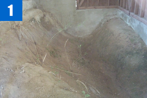
(1)Gomura Fault (Higuchi, Koike, Ikunouchi)
This is a seismic fault (18 km long from north to south) caused by the North Tango Earthquake (M7.3) on March 7, 1927. Three parts of the fault (Higuchi, Koike, and Ikunouchi) are designated as national natural monuments to preserve the movement of the fault by the earthquake.

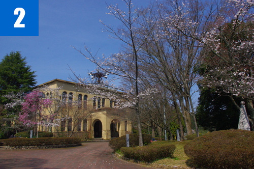
(2)Tango Earthquake Memorial Hall
This memorial hall was built in 1930 to commemorate the reconstruction of the areas affected by the North Tango Earthquake and hand down the memory of the disasters caused by the earthquake to the next generation. The building is designated by Kyoto Prefecture as a cultural asset.

(3)Mineyama Elementary School
The buildings of the elementary school that collapsed in the earthquake were rebuilt as they had been before the earthquake.

(4)Tango Earthquake Memorial Exhibition (March)
The exhibits of the memorial exhibition tell us what it was like on the day of the earthquake. We can grasp how disastrous earthquakes are and learn about the importance of preparing for natural disasters.

Kyotango City Office, Board of Education Secretariat, Cultural Assets Protection Department

Kuchiono, Omiya Town, Kyotango City

TEL

0772-69-0640

Geological Heritage
前の記事
次の記事
  • Home
  • Outline
    • Outline of Japan and Global Geopark
    • Overview of San’in Kaigan Geopark
    • Valuable and beautiful Geoheritages
    • International geological significance
    • Japanese archipelago separated from the continent
    • Wealth of Ecosystem
    • Unique people’s lives brought about by Geo
  • Geological
    Heritage
    • Kyotango City
    • Toyooka City
    • Kami Town
    • Shin'onsen Town
    • Iwami Town
    • Tottori City
  • Related
    facilities
    • San’in Kaigan Geopark Kyotango City Information Center
    • Genbudo park
    • Kami Town Geopark &Marine Culture Center
    • Shin’onsen Town Sanin Kaigan Geopark Center
    • San’in Kaigan Geopark Museum of the Earth and Sea
    • Iwami Town Nagisa Community Center
    • Tottori Sand Dunes Geopark Visitor Center
    • Aoya Folk Museum
  • Model
    course
    • San’in Kaigan Geopark Trail
    • Walk & Drive Map
  • Practices &
    Activities
  • Operating
    organization
    • Greetings from the representative
    • Introduction of Managing Board and Steering Committee
    • Introduction of constituent groups
    • Introduction of the secretariat “San’in Kaigan Promotion Council”
  • Download
  • Japanese