San’in Kaigan UNESCO Global Geopark San’in Kaigan UNESCO Global Geopark

  • Home
  • Outline
    • Outline of Japan and Global Geopark
    • Overview of San’in Kaigan Geopark
    • Valuable and beautiful Geoheritages
    • International geological significance
    • Japanese archipelago separated from the continent
    • Wealth of Ecosystem
    • Unique people’s lives brought about by Geo
  • Geological
    Heritage
    • Kyotango City
    • Toyooka City
    • Kami Town
    • Shin'onsen Town
    • Iwami Town
    • Tottori City
  • Related
    facilities
    • San’in Kaigan Geopark Kyotango City Information Center
    • Genbudo park
    • Kami Town Geopark &Marine Culture Center
    • Shin’onsen Town Sanin Kaigan Geopark Center
    • San’in Kaigan Geopark Museum of the Earth and Sea
    • Iwami Town Nagisa Community Center
    • Tottori Sand Dunes Geopark Visitor Center
    • Aoya Folk Museum
  • Model
    course
    • San’in Kaigan Geopark Trail
    • Walk & Drive Map
  • Practices &
    Activities
  • Operating
    organization
    • Greetings from the representative
    • Introduction of Managing Board and Steering Committee
    • Introduction of constituent groups
    • Introduction of the secretariat “San’in Kaigan Promotion Council”
  • Download
メニュー
  • Japanese

Geological HeritageKami Town

Amarube

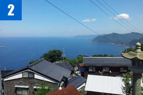
Conspicuous ria coast can be seen where mountains directly reach the sea. Due to complicated geographical features of the coast, the railway bridge, Amarube Viaduct, passes at a great height.

(1)Amarube Viaduct
A viaduct built over a deep valley of the typical coastline in Tajima. It used to be a trestle bridge some 310.59m in length and 41.45m in height opened on March 1, 1912, and a part of the old bridge is still preserved. The current bridge is a concrete extradosed PC bridge.

(2)Misaki Village
A legendary village of Heike folklore. There is a stone tower using granite called Misaki Stone in the village.

(3)Tsurigane Sea Cave
A rock tunnel formed along two dikes having a wide intersection part. 10m in water depth, approx. 40m in height, and 110m in length.

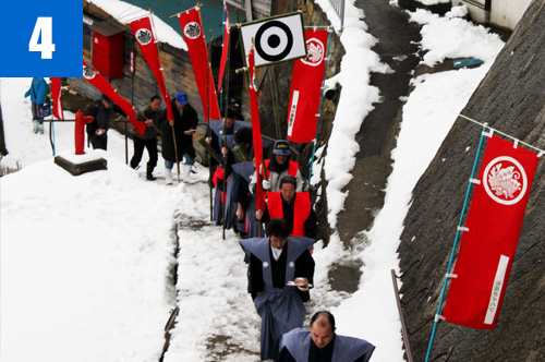
(4)Momote Ceremony (January 28)
A traditional event held in Heinai Shrine in Misaki District on January 28 hoping for the restoration of the Heike family. Three young boys costumed as soldiers named Kadowaki, Iga, and Yabiki shoot 101 arrows to the target assumed to be Genji hung on the sacred tree in the shrine premise.

Kamicho Kasumi Tourist Association

1-1 Nanukaichi, Kasumi-ku, Kami Town

TEL

0796-36-1234

URL
Geological Heritage
前の記事
次の記事
  • Home
  • Outline
    • Outline of Japan and Global Geopark
    • Overview of San’in Kaigan Geopark
    • Valuable and beautiful Geoheritages
    • International geological significance
    • Japanese archipelago separated from the continent
    • Wealth of Ecosystem
    • Unique people’s lives brought about by Geo
  • Geological
    Heritage
    • Kyotango City
    • Toyooka City
    • Kami Town
    • Shin'onsen Town
    • Iwami Town
    • Tottori City
  • Related
    facilities
    • San’in Kaigan Geopark Kyotango City Information Center
    • Genbudo park
    • Kami Town Geopark &Marine Culture Center
    • Shin’onsen Town Sanin Kaigan Geopark Center
    • San’in Kaigan Geopark Museum of the Earth and Sea
    • Iwami Town Nagisa Community Center
    • Tottori Sand Dunes Geopark Visitor Center
    • Aoya Folk Museum
  • Model
    course
    • San’in Kaigan Geopark Trail
    • Walk & Drive Map
  • Practices &
    Activities
  • Operating
    organization
    • Greetings from the representative
    • Introduction of Managing Board and Steering Committee
    • Introduction of constituent groups
    • Introduction of the secretariat “San’in Kaigan Promotion Council”
  • Download
  • Japanese